 |  |  |  |
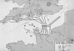
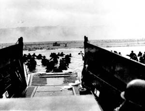
| Map of Normandy assault routes | 1944 United States Army map of the Army Rangers’ attack plan for Pointe du Hoc on the Normandy beaches set for 6 Jun 1944. Note the misspelling of Pointe du Hoc. | Map depicting Allied bomber offensive plans in the Normandy, France region and German dispositions, 6 Jun 1944 | Map depicting the Utah beachhead, Normandy, France, 6 Jun 1944 |
 |  |  |  |
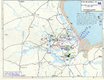
| Map noting Allied and German dispositions in southern England, United Kingdom and Normandy, France on 6 Jun 1944 | Map noting situation at Normandy, France at 2400 hours on 6 Jun 1944; note title text with deceptive American unit FUSAG | Map of Juno Beach Normandy, France showing 3rd Canadian Infantry Division D-Day landing objectives and front line as of midnight 6 Jun 1944. | Map of the Omaha beachhead, Normandy, France, showing movements of the US Army V Corps, 6 Jun 1944 |
 |  |  |  |
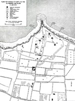
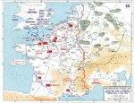
| Map showing German dispositions on Cotentin Peninsula in France on 6 Jun 1944 | US Army map of the landing beaches at Utah Beach, Normandy, France, 6 Jun 1944. Note that the planned landing beaches are about 250 yards away from actual landing beaches. | Map depicting Allied operations in the Normandy, France area, 13-30 Jun 1944 | Map depicting the Allied attempt to expand the beachhead at Normandy, France, 1-24 Jul 1944 |
 | |||
| Graphic chart of Allied advance in France, from Fiscal Years 1944-1945 Biennial Report of Army Chief from Staff General George Marshall to the US Secretary of War, Aug 1945 |
Search WW2DB
News
- » WW2DB's 19th Anniversary (29 Dec 2023)
- » Looted Painting "Madonna with Child" Returned to Poland (2 Jun 2023)
- » Wreck of USS Mannert L. Abele Found (29 May 2023)
- » Wreck of Montevideo Maru Found (25 Apr 2023)
- » Accidental Detonation of a WW2-Era Bomb in Great Yarmouth (10 Feb 2023)
- » See all news
Current Site Statistics
- » 1,147 biographies
- » 337 events
- » 43,435 timeline entries
- » 1,237 ships
- » 349 aircraft models
- » 207 vehicle models
- » 372 weapon models
- » 123 historical documents
- » 259 facilities
- » 468 book reviews
- » 28,403 photos
- » 432 maps
Famous WW2 Quote
"All that silly talk about the advance of science and such leaves me cold. Give me peace and a retarded science."Thomas Dodd, late 1945
Support Us
Please consider supporting us on Patreon. Even $1 a month will go a long way. Thank you!
Or, please support us by purchasing some WW2DB merchandise at TeeSpring, Thank you!